


I have always heard it said that the exact location of the Council Oak tree has been lost to history, and the monument that sits at the intersection of N.C. 181 and Bost Road is just “in the general area” of where the tree once stood.
Being someone who is interested in history, and especially that part of history that can be backed up by primary-source documentation, I set out to try to find the exact (or as close as possible) location where the Council Oak once stood.
For those of you who do not know the story of the Council Oak, let me enlighten you.
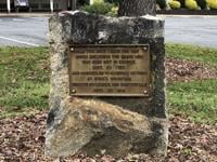
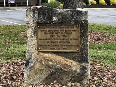
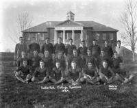
Legend has it that on Sept. 30, 1780, Col. Charles McDowell met the commanders of the Patriot Militias convened at Quaker Meadows and laid the final strategy for their advance against British Maj. Patrick Ferguson and his army of Provincials, Loyalists, and Tories.
But where did the Council Oak stand in 1780? I’ve heard people say the Council Oak tree stood “somewhere on the old Quaker Meadows Golf Course property” or “closer down towards the river” or even “somewhere near Freedom High School.” Without documentation, all those locations were just guesses, so I started digging in the historical record.
We know from the written record that the Council Oak tree was damaged in a lightning storm around 1902 and was cut down in 1905. On Oct. 1, 1914, the Council Oak Monument was placed by the DAR on the exact site of the Council Oak tree.
After the flood of 1916, the monument was relocated to a spot near where today’s St. Mary’s Church Road intersects with N.C. 181. At that time St. Mary’s Church Road did not exist, and the spot was just a small hill above the high-water mark of the 1916 flood.
Over time the monument became overgrown with brush and was forgotten. When St. Mary’s Church Road was built in the late 1930s, the monument was inadvertently pushed over and covered, and its existence completely forgotten.
In 1964 when the former Skyland Textile plant was built, the monument was discovered and its significance realized. Through the efforts of the then president of Skyland Textile, the monument was relocated to almost its present-day location. When AJ’s Restaurant was built, the monument was once again moved, but this time only several yards away to where it is today.
But again, the question begs to be answered: Where did the Council Oak tree stand in 1780?
Joseph McDowell Sr. (the father of Col. Charles McDowell) received Land Grants in 1749 and 1750. These two land grants covering the Quaker Meadows tract had as a common corner a “Red Oak.”
Unfortunately, the survey maps from the 1749 and 1750 surveys had not survived history, so the only thing I had to go on was the survey descriptions which gave the “meets and bounds” of the two surveys.
Without a map and an identifiable starting point, I had to create a new map to-scale of a modern-day aerial map of the Quaker Meadows area and see where the corners “fit” within the known area.
Fortunately, Charles McDowell Sr.’s 1779 Grant of his Quaker Meadows tract did survive and did have an attached survey map and an identifiable starting point at the “Rocky Ford” which is where today’s N.C. 181 bridge crosses the Catawba River. This starting point in the 1779 Grant matched the starting points in the 1749 and 1750 Grants.
Using Charles McDowell Sr.’s 1779 Grant meets and bounds as points of reference, I drew a new map to scale with the modern aerial map and the two newly created to-scale maps from the 1749 and 1750 Joseph McDowell Sr. Grants.
Using the N.C. 181 bridge across the Catawba River (the “Rocky Ford”) as a point of reference, I overlayed all three maps and found they converged at the “Red Oak” mentioned in the 1749 and 1750 Grants and that “Red Oak” was just about exactly where the present-day Council Oak Monument is located.
I would be willing to say, with an extremely high degree of certainty, that the Council Oak Monument is located today within less than 20 yards of where the Council Oak tree stood in 1780.
So, after all these years and after several moves, by sheer coincidence, the Council Oak Monument today appears to be just about exactly where the tree stood in 1780 when, as legend has it, the Patriot leaders met to plan the final push against Ferguson and their ultimate victory at the Battle of Kings Mountain.


(0) comments
Welcome to the discussion.
Log In
Keep it Clean. Please avoid obscene, vulgar, lewd, racist or sexually-oriented language.
PLEASE TURN OFF YOUR CAPS LOCK.
Don't Threaten. Threats of harming another person will not be tolerated.
Be Truthful. Don't knowingly lie about anyone or anything.
Be Nice. No racism, sexism or any sort of -ism that is degrading to another person.
Be Proactive. Use the 'Report' link on each comment to let us know of abusive posts.
Share with Us. We'd love to hear eyewitness accounts, the history behind an article.