

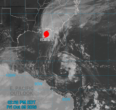

Burke officials said the emergency operations center is stood up, but not activated, and emergency services are engaged ahead of Hurricane Isaias creeping across the county.
“This is not Helene. We’ve got to reiterate that,” Burke County Public Information Officer Chris White said. “It’s vast. It’s going to be here. It’s going to rain a lot. It’s gonna be gone.”
White said he’s expecting about 2-4 inches max in Morganton.
His main concern is along the eastern slopes of the Blue Ridge, where he expects winds around 50-60 miles per hour on top of about 3-6 inches of rainfall.
The trigger for landslides is more than 5 inches of rain in 24 hours, and White said, “We’ll come close.”
However, he expects that if dangerous conditions arise, they’ll be highly localized, and most places will simply get rainfall. White said the heaviest downpour will likely be between about 11 a.m. Saturday and 2 a.m. Sunday.
Either way, the State Emergency Response Team (SERT) is in the process of deploying teams across the state and, coincidentally, Burke County Emergency Services will be hosting a swiftwater response training for multiple water rescue teams from across the state this weekend.
The training was planned months in advance, meaning several rescue teams will be in the area, just in case.
“We’re ready,” White said. “We learned a lot during Helene. Our public information offices are working together with the different municipalities. If it gets to the point where we need to get information forward, we’re gonna flow information freely during the storm.”
FROM THE NATIONAL WEATHER SERVICE
The National Weather Service Greenville-Spartanburg has placed the area under a Flood Watch beginning at 8 a.m. Saturday through Sunday afternoon. According to the alert, excessive runoff may result in flooding of rivers, creeks, streams, and other low-lying and flood-prone locations. Creeks and streams may rise out of their banks. Low-water crossings may be flooded.
As Hurricane Isaias weakens and moves northward through early Saturday, rain will become increasingly likely across the western Carolinas and northeast Georgia. Periods of rain could begin before dawn Saturday, though rainfall rates will initially be light. Rainfall rates will increase during the day, and heavy rain is most likely Saturday afternoon through early Sunday morning, particularly along the south- and east-facing Blue Ridge Escarpment near the southern border of North Carolina west of I-26, and in the sharp terrain from near Saluda to Grandfather Mountain in North Carolina.
WHAT A FLOOD WATCH MEANS
A Flood Watch for flash flooding means there is a potential for rapid-onset flooding based on current forecasts. Flash flooding is a very dangerous situation and may impact areas that do not typically flood. Monitor the latest forecasts and be prepared to act quickly should Flash Flood Warnings be issued.
Rainfall of more than 5 inches in similar storms has been associated with an increased risk of landslides and rockslides. If you live on a mountainside or in a cove at the base of a mountain, especially near a stream, be ready to leave in advance of the storm or as quickly as possible should rising water, moving earth, or rocks threaten. Consider postponing travel along mountain roads during periods of heavy rainfall.
WEEKEND FORECAST (as of 3 p.m. Friday)
Tonight: A 20% chance of showers after 2 a.m. Cloudy, with a low around 55. Light north-northeast wind.
Saturday: Showers, with thunderstorms also possible after 5 p.m. Patchy fog after 11 a.m. High near 63. Northeast wind 8 to 14 mph, with gusts as high as 28 mph. Chance of precipitation is 90%. New rainfall amounts between three-quarters of an inch and 1 inch possible.
Saturday Night: Showers and possibly a thunderstorm. Patchy fog before 9 p.m. Low around 60. East-northeast wind 8 to 13 mph, with gusts as high as 29 mph. Chance of precipitation is 100%. New rainfall amounts between 1 and 2 inches possible.
Sunday: Showers likely and possibly a thunderstorm. Mostly cloudy, with a high near 72. Northeast wind around 8 mph becoming south-southwest in the afternoon. Winds could gust as high as 21 mph. Chance of precipitation is 70%.
Sunday Night: A 30% chance of showers before 8 p.m. Partly cloudy, with a low around 60.





























(0) comments
Welcome to the discussion.
Log In
Keep it Clean. Please avoid obscene, vulgar, lewd, racist or sexually-oriented language.
PLEASE TURN OFF YOUR CAPS LOCK.
Don't Threaten. Threats of harming another person will not be tolerated.
Be Truthful. Don't knowingly lie about anyone or anything.
Be Nice. No racism, sexism or any sort of -ism that is degrading to another person.
Be Proactive. Use the 'Report' link on each comment to let us know of abusive posts.
Share with Us. We'd love to hear eyewitness accounts, the history behind an article.