




A river, like a human, a deer, or a towering cedar tree, is a living organism.
Moving water is a force. Given time, it cuts new boundaries, clears new channels, and changes courses.
The key words there are “given time,” because such changes are usually incremental, measured in years or centuries, not days or hours.
A torrential summer thunderstorm, dumping 3 to 4 inches of rain over a watershed in a few hours, quickens that equation, of course.
A hurricane like Helene quickens it exponentially, turning the Linville River from a gentle mountain stream as it flows out of the Gorge toward Lake James into a surging torrent.
According to figures provided by the U.S. Forest Service, the normal flow of the Linville at a monitoring station just south of Linville Gorge is a little less than 100 cubic feet per second.
On Sept. 27, 2024, when Helene was hammering Western North Carolina with all of her fury, the flow at that monitoring station reached 28,300 cubic feet per second – an advancing wall of water of extraordinary power.
On a typical day, the Linville River carries a little less than 750 gallons of water past the monitoring station every second. During Hurricane Helene on Sept. 27, 2024, that figure exploded to nearly 212,000 gallons per second — more than 280 times its normal flow.
To put that into perspective, the river was carrying enough water to fill an Olympic-size swimming pool in just over three seconds. In a single minute, approximately 12.7 million gallons of water rushed past the station — enough to fill about 19 Olympic-size pools.
The figures measure the volume of water passing a fixed point, not the speed of the current. But they illustrate the enormous force of a river transformed by Helene from its usual flow into a devastating flood.
At the height of Hurricane Helene, the Linville River was carrying nearly 900 tons of water every second — an astonishing 53,000 tons per minute — as floodwaters roared through the gorge.
THE CONNECTOR TRAIL
One of the most interesting hiking trails in Burke County is the Connector Trail, which, as the name implies, connects the Fonta Flora Trail near Lake James to the Mountains to the Sea Trail.
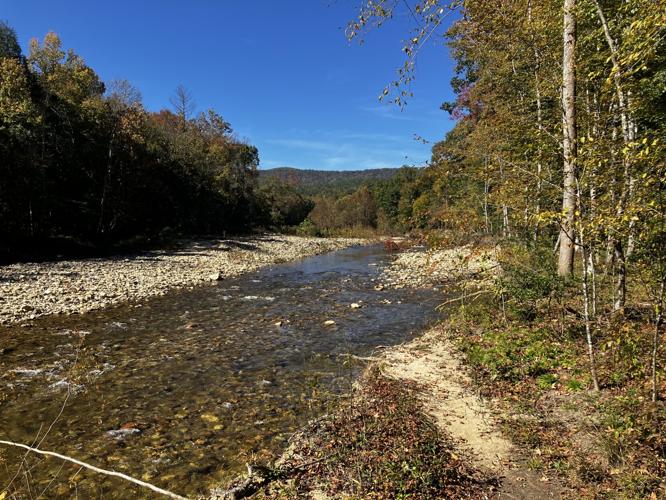
More than a mile of the trail is directly adjacent to the Linville River, providing the perfect viewing point to survey the impact of both Helene two years ago and the remnants of Hurricane Isaias which moved over the county just three weeks ago.
The access point where Brother Johnny and I start the Connector Trail is a tiny pull-off on N.C. 126 between the Wolfpit Road and the Linville River Bridge. The area is big enough for only a few cars. Blink and you’ll miss it. There is no sign.
Johnny and I hiked the trail on Monday, Oct. 26, a picture-perfect mid-autumn day with blue skies, brilliant sunshine, and chilly morning temps that would warm to the upper 60s by late afternoon.
Our trek marked the first “serious” hiking I had done in nearly two and a half months, as ongoing cardiac concerns left me temporarily grounded. When my restrictions were lifted, Johnny immediately proposed the Connector.
The trail has a couple of steep climbs on it, but neither is particularly lengthy. A couple of rock-hopping stream crossings are thrown in for good measure, and parts of the trail are very rooty and rocky.
In other words, the perfect location to try out my trail legs after a long absence and to see just how out of shape I was.
The trail begins an immediate ascent through a mostly pine forest to the top of a ridge. It then descends just as quickly, although for a longer distance, before emerging, at about the 1-mile mark, on the banks of the river.
At least five years had passed since I last hiked the Connector Trail on a day when Johnny and I continued from its terminus up to the summit of Shortoff Mountain — a strenuous trek of more than 10 miles roundtrip.
No such feats of derring do were planned on this morning, just a lazy amble along the Linville, taking in the sights and hoping for a glimpse of an eagle or an osprey fishing the stream.
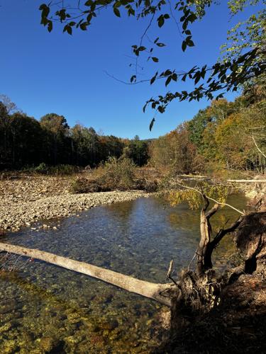
As soon as the river came into sight, I was shocked by how much it had changed since I last walked along its banks.
The overwhelming first impression was of how many rocks — ranging from boulders to baseball-size stones, had been deposited along the banks of the river.
At places, the stones were so uniform that it looked as if the work had perhaps been done intentionally by human labor.
My second thought was of how much wider the channel was now than it had been several years ago. Streamside campsites that had been in place for years were simply gone, the earth beneath them washed away.
Any number of large trees, which years ago would have been well back from the river channel, were now perched perilously along the sharply eroded banks. And we also witnessed a towering poplar tree, its leaves still green, that had lost its tenuous grip on the soil and tumbled fully into the water.
How frightening would it have been, I wondered, to have stood in these woods on the morning of Sept. 27, 2024, and watched the full force of those rampaging waters at work?
Standing there on the banks of the Linville, looking at the boulders scattered across the floodplain, the freshly carved banks and the trees that had surrendered to the current, I was reminded that a river is never really finished shaping its world.
Given time, it works quietly, almost imperceptibly. But every so often, nature reminds us that time can be compressed into a few terrifying hours, leaving behind a landscape that may never look quite the same again.
Helene had come and gone, but the Linville still bore the scars of its fury, a sobering reminder that even the most familiar places can be transformed in the blink of an eye.
EPILOGUE:
Our hike, roundtrip, ended up being just a hair over 4.5 miles. Our hiking time was a little more than three and a half hours. The trek was the perfect reintroduction to the glories of the woods in Burke County.
I suffered no ill effects from the activity, indeed just the opposite. I felt energized and renewed from my time outdoors in the October sunshine.
I can recommend the Connector Trail to others as a very nearly perfect excursion — parts of it challenging, parts of it easy, all of it beautiful.
My favorite two months for hiking are November and December, as the leaves fall, the vistas open up, and all the world seems to turn toward home.
And, brothers and sisters, I am looking forward to enjoying them fully.

























(0) comments
Welcome to the discussion.
Log In
Keep it Clean. Please avoid obscene, vulgar, lewd, racist or sexually-oriented language.
PLEASE TURN OFF YOUR CAPS LOCK.
Don't Threaten. Threats of harming another person will not be tolerated.
Be Truthful. Don't knowingly lie about anyone or anything.
Be Nice. No racism, sexism or any sort of -ism that is degrading to another person.
Be Proactive. Use the 'Report' link on each comment to let us know of abusive posts.
Share with Us. We'd love to hear eyewitness accounts, the history behind an article.