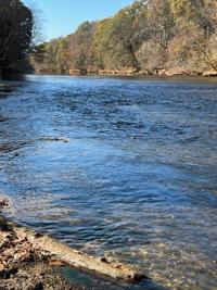
Duke Energy will be making adjustments to the water flow in its lakes as the drought continues. This photo is off the Catawba River during the autumnal drought of 2023.
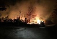
Forest fires, like this one in the Linville Gorge area of Burke County in 2016, are a serious threat right now thanks to severe drought conditions.
N.C. FOREST SERVICE / FOR THE PAPER
Thinking of going camping in South Mountains State Park and building a roaring fire around which to roast weenies and tell tall tales?
Forget it.
Wanting to burn off the garden space in the backyard before doing the spring planting?
No, no, no!
Burke County is under a local and a statewide burning ban.
Local officials up and down the Catawba River Basin are eyeing water flow rates and looking hopefully to the skies for any sign of rain in the hope that water use restrictions or water rationing can be avoided in the summer months ahead.
So too are farmers, who are watching their pastures wither and their animals deal with unseasonal heat.
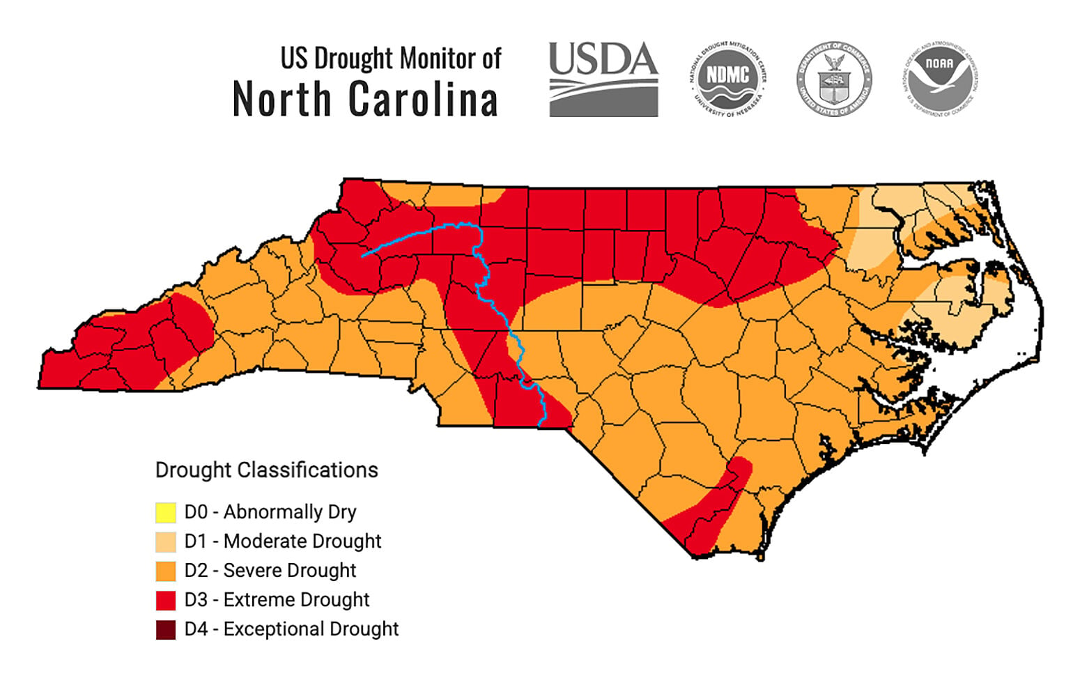
Drought, indeed severe drought, has returned to Burke County and indeed the entire state of North Carolina and its impacts are already being felt.
The question now is how bad will it get before it gets better?
HISTORICAL PERSPECTIVE
Droughts, meteorologists will tell you, are not born overnight. They are bred by month after month of below normal precipitation.
Nor, the same experts will explain, are they brought to an end by a single heavy thunderstorm, even if that storm quickly dumps two to three inches of rain upon thirsty local soil.
The extended dry spell that has led to Burke and surrounding counties being labeled in a state of “severe drought” by the National Weather Service began in early September of 2025.
And, full recovery from this drought will require months of above-average rainfall. Not days, not weeks … months.
Droughts have been common in Burke County in the 21st century.
The late summer and early autumn of 2023 were “dry as dust” in Burke County, and The Paper reported weekly on the drought status.
2016 also saw a “flash drought” in Western North Carolina which resulted in an unusually active fire season that left Burke County thick with smoke from forest fires across the region for a couple of weeks in early November.
The most severe drought of the last two decades began in the summer of 2007 and continued through the spring of 2008.
Remembers Damon Pollard, with the Burke Center of the N.C. Cooperative Extension, “I had never seen it so dry. We had to have hay flown in to feed cattle. Everything here was just parched.”
THE CAUSES OF THIS DROUGHT
While drought conditions are affecting most of the Southeastern United States, its root cause, according to Morganton meteorologist Jason Prichard, lies in the South Pacific.
“La Niña and El Niño refer to the sea water surface temperatures to the west of South America,” Prichard said.
“When we are dealing with La Niña, those waters are cooler and they tend to push the storm track up near the Canadian border,” Prichard explained.
“When El Niño sets up, the surface ocean temps are warmer, the storm track lies farther south, and we can usually depend upon more rain here.”
Certainly, the impact of La Niña has been evident in Burke County since last September.
Both November and March were exceptionally dry, with only .92 of an inch of rain recorded in Morganton compared to the average of 3.75 during November. In March, normal average rainfall is 4.38 inches; this year it was only 1.55.
Overall, from Sept. 1, 2025, to April 15, 2026, Morganton rainfall was 16.68 inches compared to the norm of 24.93 inches.
While a change in that pattern may be coming, the situation is not entirely black or white, Prichard cautioned. Pockets of La Niña waters can remain in an overall El Niño situation and vice versa. And the time of transition from one to the other can also vary.
Given all that, however, Prichard said an El Niño situation is setting up that should bring better chances of precipitation in the next few weeks.
“At some point, it will shake up, it will change,” said Prichard, “but it is impossible to predict exactly when that will happen.”
A final note about El Niño. When it is affecting the weather in the Southern United States, strong tropical storms or hurricanes are less likely to form than under a La Niña situation.
Such storms can bring horrific damage (think Helene), but they can also bring heavy rains that serve to replenish depleted lakes and reservoirs.
IMPACT OF DROUGHT
Water Supply:
As of Thursday, the entire length of the Catawba-Wateree river system, as managed by Duke Energy, is in Stage 1, meaning that river flow is below average, but no water use restrictions are currently in place.
Residents all along the Catawba River basin are now encouraged to begin conserving water.
“Water is obviously our most valuable resource,” said Morganton Water Resources Director Randy Smith. “Fortunately for us, Lake James is a tremendous water resource and so far, we’re in good shape so far as river flow.”
Should the drought continue unabated for some time, the city will move into implementing its Water Shortage Management Plan, which was revised in May of 2023.
During Stage 1, the city will encourage its customers to reduce their water usage and improve their water use efficiency but there will be no penalties for noncompliance.
Duke Energy will be making adjustments to the water flow in its lakes as the drought continues. This photo is off the Catawba River during the autumnal drought of 2023.
MARTY QUEEN / THE PAPER
Stage 2 and then Stage 3 would be implemented if the Catawba River drops significantly lower than the seasonal norm and if weather experts predict drought conditions are likely to continue, Smith explained.
These two stages would require mandatory reductions in water use and customers who failed to meet the reduction targets would have to pay penalties.
Stages 4 and 5, which would be implemented only after a long and severe drought, would first incur emergency reductions and then rationing of water by the city.
Smith did point out, however, that over the past 20 years, neither Stage 4 nor Stage 5 has ever been implemented.
“Duke Energy is basically in control of how much water moves down the chain and what the lake levels are,” Smith added. “But they do an excellent job of balancing needs with supply.”
Agriculture:
Although the flow of the Catawba River remains sufficient to make water restrictions unlikely in the near future, the drought is already impacting the land, plants, and animals across Burke County.
“A lot of our farmers have been waiting for rain to plant their corn,” said Pollard. “And we’re approaching the point where that crop will not be viable.”
Already stunted by the lack of spring rain, Pollard said, are pastures and hayfields across the county.
“The pastures are really not growing very much,” Pollard said, “and the high temperatures are forcing cattle to seek shade in the day and doing their eating at night.”
Pollard said the unusually hot temperatures for late March, and the first half of April are forcing chicken farmers to use cooling fans in their chicken houses much earlier than normal.
“Obviously,” he said, “that’s going to dramatically increase their power bills and cut into their ultimate profit margin.”
While Pollard is hopeful that a shift in the weather pattern is coming, he is realistic that full recovery from this drought will be slow in coming.
“The N.C. Cooperative Extension estimates that we need 35 inches of rain to put things back to normal,” he said. “That won’t happen overnight, even if we get a tropical event or two later in the summer.”
Burn Ban:
In response to the abnormally dry soil and forest conditions, the N.C. Forest Service instituted a statewide burn ban on Saturday, March 28, and the Burke County Fire Marshal’s office put a local burn ban in place on the same day.
This means no campfires are permitted in either Lake James or South Mountains State Parks. Instead, campers must use portable gas stoves or grills.
Also now forbidden are fireworks shows of any kind, meaning minor league ballparks across the state — including L.P. Frans Stadium, home of the Hickory Crawdads — will have to cancel all pyrotechnic displays until the burn ban is lifted.
Gas grills and smokers may continue to be used.
Longtime Burke County residents well remember in April of 1985 when a person burning trash outdoors during a burn ban sparked a wildfire that swept from the George Hildebrand area up the South Mountains and then leapt across I-40 and into Valdese.
The fire burned more than 5,000 forested acres and destroyed 27 homes, several of them atop Mineral Springs Mountain.
THE IMMEDIATE FUTURE
Sunday, April 19, brings the chance of a passing shower to Burke County, but the National Weather Service says less than .05 of an inch of rain is expected.
The cold front providing that small rain chance will deliver a big change, however, in the form of much cooler temperatures. Sunday’s high is expected to be only 67 and the low Monday morning will be 41.
Monday’s high is expected to be around 70, but the low Tuesday morning will be a nippy 37 degrees.
And after that … no significant rainfall is expected through the end of the month.
Bill Poteat is editor emeritus. He may be reached at 828-445-8595 or bill@thepaper.media.
Keep it Clean. Please avoid obscene, vulgar, lewd,
racist or sexually-oriented language. PLEASE TURN OFF YOUR CAPS LOCK. Don't Threaten. Threats of harming another
person will not be tolerated. Be Truthful. Don't knowingly lie about anyone
or anything. Be Nice. No racism, sexism or any sort of -ism
that is degrading to another person. Be Proactive. Use the 'Report' link on
each comment to let us know of abusive posts. Share with Us. We'd love to hear eyewitness
accounts, the history behind an article.


(0) comments
Welcome to the discussion.
Log In
Keep it Clean. Please avoid obscene, vulgar, lewd, racist or sexually-oriented language.
PLEASE TURN OFF YOUR CAPS LOCK.
Don't Threaten. Threats of harming another person will not be tolerated.
Be Truthful. Don't knowingly lie about anyone or anything.
Be Nice. No racism, sexism or any sort of -ism that is degrading to another person.
Be Proactive. Use the 'Report' link on each comment to let us know of abusive posts.
Share with Us. We'd love to hear eyewitness accounts, the history behind an article.